Wolchulsan: 810.7 m Summit, 6 Official Trails and Free Parking
Wolchulsan National Park in Jeonnam rises to 810.7 m at Cheonhwangbong. This guide covers its 6 official trails with times and difficulty, free car parks, the nearest emergency rooms and pharmacies, and where to stay or camp.
Data as of 2026-10-20
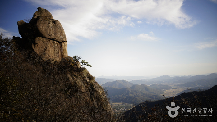
Wolchulsan National Park lies in Wolnam-ri, Seongjeon-myeon, Gangjin County, in South Jeolla (Jeonnam). According to the Korea Tourism Organization, it is the smallest national park in the country, and its odd-shaped rocks look like an exhibition of scholar's stones. The highest point is Cheonhwangbong, at 810.7 m. The park is compact, but it is still worth choosing your entrance and your trail before you set off.
What kind of mountain is it?
The Tourism Organization describes a steep rocky face to the north and gentler, softer slopes to the south. Together with Jirisan, Byeonsan, Cheongwansan and Naejangsan, it is counted among the five famous mountains of the Honam region. It was called Wolnasan in the Silla period and Wolsaengsan in Goryeo, and has been Wolchulsan since the Joseon era. It became a national park in 1988. Nearby are the Geungnakbojeon Hall of Muwisa Temple (National Treasure No. 13) and the Haetalmun Gate of Dogapsa Temple (National Treasure No. 50). A seated Buddha carved in rock near the Yongamsa temple site below Gujeongbong Peak, National Treasure No. 144, is also well known.
Trails: six official routes
The park lists 6 official trails: 1 easy, 2 moderate and 3 hard. The times below are the published ones. Allow extra for rest stops and weather.
| Trail | Difficulty | Time |
|---|---|---|
| Cloud Bridge (구름다리) | Easy | 2 h |
| Sanseongdae car park to Gwangamteo junction (산성대주차장~광암터삼거리) | Hard | 2 h |
| Gyeongpodae area to Cheonhwang area (경포대지구~천황지구) | Moderate | 3 h 10 min |
| Dogap area to Gyeongpodae area (도갑지구~경포대지구) | Moderate | 3 h 40 min |
| Cheonhwang area loop (천황지구~순환코스) | Hard | 4 h |
| Ridge traverse via Baram Falls (종주코스) | Hard | 6 h 30 min |
For a first visit, the Cloud Bridge trail, rated easy, is the sensible choice. The full ridge traverse takes 6 hours 30 minutes, so start early. The park data lists no mountain shelters, so bring your own water and food.
Parking: free car parks near the entrances
The national parking registry lists five car parks within 3 km, and all five are recorded as free. The two closest sit beside the park's visitor support centres.
| Car park (Korean name) | Measured from | Distance | Spaces | Fee | Hours |
|---|---|---|---|---|---|
| Dogapsa (도갑사) | Dogap visitor centre | 330 m | 150 | Free | 08:00-17:00 |
| Wolchulsan Cheonhwangsa car park (월출산 천황사 주차장) | Wolchulsan visitor centre | 470 m | 250 | Free | 08:00-17:00 |
| Gunseo five-day market (군서오일장터) | Dogap visitor centre | 2.2 km | 85 | Free | 00:00-23:59 |
| Seonggi-dong tourist site (성기동군민관광지) | Dogap visitor centre | 2.57 km | 163 | Free | 08:00-18:00 |
| Wangin Doctor (왕인박사) | Dogap visitor centre | 2.57 km | 550 | Free | 08:00-18:00 |
This is registry data and may differ on site. The two nearest car parks are listed as closing at 17:00, so check before a late descent. Eleven toilets are registered nearby.
If you need a doctor
The nearest emergency rooms are Yeongam Korea Hospital (영암한국병원), a regional emergency medical institution 2.7 km away, and Jeollanam-do Gangjin Medical Center (전라남도강진의료원), also regional, 12.9 km away. Three pharmacies stand 2.8 km away: Bubu (부부약국), Geongang (건강약국) and Pureun (푸른약국). Only Pureun is listed as open on Sundays. In an emergency, call 119; for accidents at sea, call the Korea Coast Guard on 122.
Where to stay
Within 3 km there are 9 licensed places to stay: 4 motels and inns, 4 residence-style lodgings and 1 other. Pensions and farm-stay minbak are registered under a different system and are not counted. For camping, Cheonhwang Campground (월출산국립공원 천황야영장) is the closest at 1.6 km. After that come Yeongam Public Leisure Campground (영암군 국민여가 캠핑장) at 2.8 km, ROCKON Glamping at 3.2 km and Stayfun Glamping (스테이펀 글램핑) at 3.3 km.
Distances are straight-line. Opening hours and fees can change, so check again before you travel. Emergency 119 · Coast Guard 122
- Ministry of the Interior and Safety, national parking registry (records dated 2026-03-11 to 2026-10-01)
- National Medical Center, emergency departments (retrieved 2026-10-11)
- National Medical Center, pharmacies (retrieved 2026-10-11)
- Ministry of the Interior and Safety, lodging licences (retrieved 2026-10-11)
- Ministry of Oceans and Fisheries, beach visitor statistics (2015 to 2024, retrieved 2026-10-11)
- Ministry of the Interior and Safety, public toilets (retrieved 2026-10-10)
- Korea Tourism Organization GoCamping (campsites) (retrieved 2026-10-10)
- Korea Coast Guard station locations (retrieved 2026-10-11)
- Ministry of Oceans and Fisheries, beach water quality tests (2025 season tests, retrieved 2026-10-10)
- Korea Tourism Organization English tourism data (names, addresses) (retrieved 2026-10-10)